
Image Missing
ha giang
Getting to know...
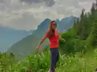
Our journey starts when we get dropped off about 5km outside of Dong Van town on the loop road where we pick up a local trail. The path is the usual 1m wide type that is popular in the region. Because of our helping hand start, the views are already amazing of the valley below. This route is really only used by local villagers and people of remote communities, so no tourists.
We head up the mountain that is heavily forested and lush with a variety of different grasses and flowers. This area is unsuitable for growing rice, so corn is grown instead.
There are a few hamlets on this path who’s inhabitants are from the Hmong tribe. This narrow path is the only way to get around so we see the occasional farmer who use the path when they access their ‘fields’, so we often chat as they don’t get many visitors. As this place is so remote - none of the houses have running water, so there is a water well locals can use along the path. There is also a very small local school for the children.
*These treks are options as in more recent times people prefer to see the big and spectacular sights. The treks are beautiful but on a tight schedule we give you the option so they are here as part of the Grand Tours as people have more time to explore and enjoy Ha Giang.
they are friendly. we can see their house if you wish. they are classic construction. mud, sticks stone. super cheap to make. they are so remote - happy to see visitors.
*this community is super poor. if you can donate old clothing or anything. they super happy for it. shoes. etc. anything. pens / paper/ school stuff. etc. the school is near the road, so we are soon at the end of the trek. where we get pickup. see the sweet river. pine trees hmong hmong village see the plateau . .. flat down the valley some more