
Image Missing
ha giang
Getting to know...
This is the most asked for trek in the Ha Giang region. This path snakes around the mountains, passing small hamlets who’s inhabitants somehow manage to farm the rocky landscape. The real attraction are the views. In recent years the path has been improved a lot and is now two metres wide! Before brown trousers were the standard for foreigners who travelled this route. There are two versions of this route depending on how long your Ha Giang adventure is.
For the Skypath, riding on a motorbike is now forbidden for tourists because the Vietnam government was upset having to pick up the remains of foreign tourists who just went straight over the side with their rented motorbike they didn’t have a licence for. Today we trek the route. If you have vertigo - please let us know before hand & we can discuss if this trek is suitable for you.
The short route
We get dropped off by our driver at the monument to the builders of the peace road. From there we start our journey which gets epic rather quickly. Walking along a narrow path - we quickly find amazing unobstructed views for us to take pictures. You can see the Nho Que river far below, as well as many limestone karsts. Please take extra care in this section of the trek especially when taking photos as the side of the path is vertically down with no barrier or fencing. We continue on to the finger pointing rock formation. Another popular photographic point.
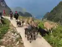
Past the finger pointing rock, we descend the other side to the tiny village of White Hmong people where we see them farming this rocky area. The children are eager to say hello to tourists - the adults are usually busy toiling on the harsh landscape. We carry on as the path winds round a couple of giant limestone formations. Soon we find ourselves with a view of Pai Lung village below meaning the end of our trek is near. The path continues on and we soon find ourselves at the roadside where our driver is ready to pick us up.
The long route
The longer route has a slightly different ending. On the short route we descended to the Ma Pi Leng Pass to join our driver. On the long version, this version - we stay high up on the mountain side and carry on along the White Cliffs (also known as Magic Cliffs and White Mountain).
We have crazy views of the landscape below. To help us on our path - for once in vietnam there are some railings to stop us falling down the side as this part of the path is literally on the side of a cliff. The path is narrow to say the least. Along the path is covered with yellow wasabi flowers.
Incredibly we see locals on this part of the trek. They gather the grasses to feed their animals on their home farm as well for fire as this part of the province does not have bamboo anywhere. The views continue to be amazing as we trek along the side of the cliffs and even enter a cave like recess in the cliffs. The path goes up and then after goes down for 2km.
We continue to the Tu San Viewpoint where the path gets easier, but has a steep descent, luckily there are some steps here to help. Lots of steps in fact. Further down we pass some houses, now the path just descends to the roadside which is nearly the end of our trek.
Lastly on to a point called Panorama Viewpoint. Here we can see the Tu San canyon from this viewpoint as well as the Nho Que river below. Stopping here for a while as its rather beautiful as well as time for us to catch our breath. This is where we end this incredible trekking experience. Our driver picks us up from here.
*The total for the trek up to 3hrs depending on pace and around 5-6km distance.