
Image Missing
sapa
Getting to know...
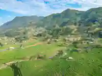
Trekking in Sapa is dominated by the Muong Hoa Valley, which stretches across the basin of the mountain range. Spanning 20km in length and home to around 30,000 people, the valley is the primary location for our trekking activities.
The villages in the valley closer to Sapa are more accessible and, as a result, have become more developed in recent years. Further out, some villages are still difficult to reach due to steep gradients and lack of access roads so remain largely closed off to outsiders. The main ethnic groups in the valley are the Red Dao, Giay, and Black H’mong.
The valley is renowned for its extensive rice terraces, benefiting from particularly fertile soil. Situated at the bottom of the valley is, of course, the Muong Hoa River. This river is seasonal in nature, with its flow varying significantly between the dry and wet seasons.
Muong Hoa River
The river get its name because its location as the main river in the Muong Hoa Valley. The river begins from the foot of Silver Waterfall, about 12 kilometres north of Sapa, and winds its way through the valley, passing through several minority villages including Lao Chai, Ta Van, and Hau Thao. These villages are home to ethnic groups such as the H’mong, Red Dao, and Giay. The inhabitants use the river for irrigation, which supports their main livelihood of rice farming. There are a few crossings, mostly basic suspension bridges that are big enough for people and motorbikes only.